

Highway

We know how hard your day to day is. Planning routes is a tedious job that requires a lot of concentration and experience. From Routal.com we want to help you, that's why we launched a series of training pills to help you improve day by day. Our goal is for you to plan better, faster and more successfully.
Shall we start?
In today's post, we'll talk about one of the biggest problems: georeferencing, or Geocoding in English. This term refers to being able to convert a written address into coordinates (GPS) on a map.
This fact, which may seem so trivial and obvious, is a very complicated process indeed. How many times has Google Maps taken you to the wrong place? In my personal case, dozens if not hundreds of times. And I have a personal anecdote, in the middle of the Swiss Alps, snowing and carrying a heavy suitcase, I sent my wife and me to the other end of town. That's a long time ago, but I'll never forget it...
This anecdote cannot happen in your daily life. Your business depends on it. Luckily your delivery people know the areas well and have no problem getting to the places. (A secret, they were lost many times before and now they have already learned 😉)
How can we better geolocate?
Very simple, following a few small formatting tricks depending on the place you want to geolocate. These are our recommendations after working with all of these countries and finding a way to be the most successful.
Argentina	Pedro Moran 5002, 1419 Ciudad de Buenos Aires, Argentina.
Australia	Macquarie St, 6 Sydney NSW 2000, Australia
Brasil	Rua Barão de Iguape, 681 – Liberdade, São Paulo
Chile	San Pablo 1130, Santiago, Región Metropolitana, Chile
Colombia	Carrera 14 112 96, 110111, Bogota D.c., Colombia
España	Calle de Azcona, 17, 28028, Madrid, España
USA	895, 29 Ave, San Francisco, CA 94121, United States
Mexico	Calle Tlaxcala, 151, 06100, Cuauhtemoc, CDMX, Mexico
Peru	Avenida 28 de Julio 1595, 15048 Miraflores, Peru
By following this recommendation, you will achieve much more success when it comes to geolocation, either by manually uploading your addresses or by importing them in bulk using an XLSX file.
Bonus track — Importing GPS coordinates on Highway
The world of geocoding changes radically when we have the GPS coordinates of the places we want to go to. In this case, the concept is called reverse-geocoding, or reverse georeferencing, which tries to convert GPS coordinates into a street and a number. This work is very simple on the part of map systems and the error is usually minimal.
The good news is that you can use GPS coordinates directly on the Highway platform and our system will do the reverse geocoding for you.
We simply have to copy the coordinates following this format:
Latitude, longitude
41.387021, 2.170123
It is important to keep the decimal separator with the dot and the separator between latitude and longitude with a comma. This is the Anglo-Saxon format, which we will find in most map systems (Google Maps, HERE, OSM,...).
We hope it was useful and we look forward to seeing you next week!

We know how hard these days are. Planning routes on a daily basis is a tedious job and since Smartmonkey.io we want to help you, that's why we launched a series of training pills to help you improve your daily life. We want you to better plan your work and for that, training can help you gain that plus.
In today's episode, we'll be optimizing by defining Delivery Zones. This strategy is the most common in any distribution and logistics company to solve the daily problem of route optimization.
This is a very complex problem, also called Traveller problem, and given the large number of possible solutions ( Factorial of the number of places to visit) and the limitations of our brain, humans developed a strategy to simplify the problem called Divide and Conquer developed in ancient Rome and with great uses today. This strategy or algorithm tries to reduce the problem into smaller problems in order to arrive at a solution in a reasonable time.
It may seem like the most successful and efficient strategy to solve this problem, but in many cases it generates a loss of efficiency if all the routes are analyzed together. The typical example of lack of efficiency can be found in the use of zip codes as a zoning system. When a fair order is on the border of the next zip code and all other services in that zip code are away from this one.
Postal codes, since they are not generated based on the concentration of services, generate fictitious boundaries that impact the performance of distribution operations, although at the same time they help to streamline the organization and sorting of the distribution.

Black and white people don't exist in logistics, and that's why right now is where other very important external factors come into play. The time and experience of the delivery people.
In logistics, there is nothing more expensive than time. Therefore, any action aimed at reducing time is always very welcome. In the example above, dividing by zip codes is a simple job, anyone is able to make groups by a predefined code. For this reason, that strategy is good and is widely used. It is a decisive strategy in a short space of time with acceptable performance.
The other key factor is the delivery person's experience. Our customers tell us that experience can make a performance difference of more than 3x between an expert worker and a non-skilled worker. So it's a very important variable to consider.
The objective is to be able to plan a route achieving good results in a very short time without having experience.
Smartmonkey goal
To this end, defining areas that represent the deliveryers' experience together with a route optimization system can be a good strategy.
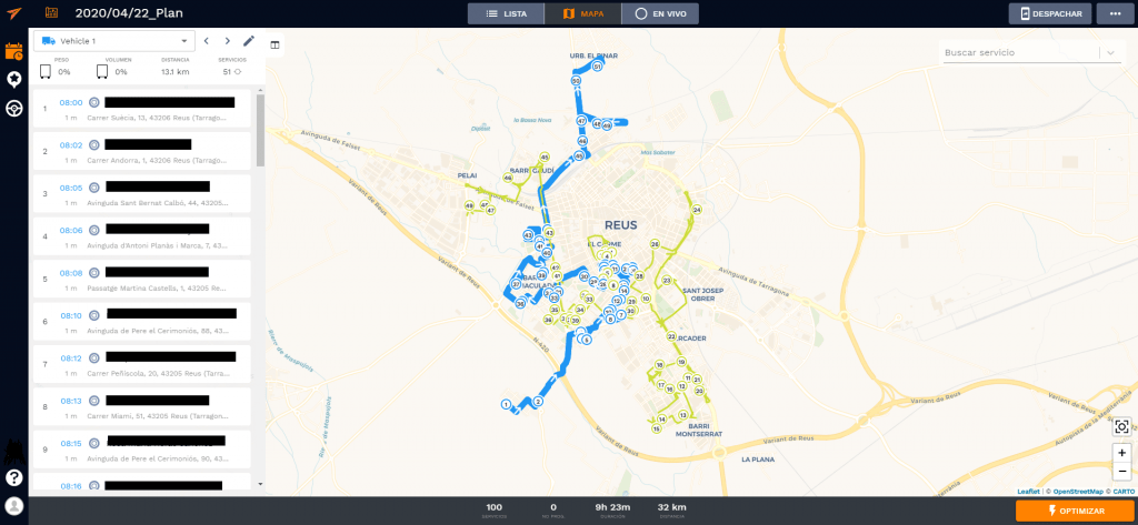
How do we define a zone in Highway?
A zone is an area where all the services included in it share the same attribute. For example, they are part of zone 1. Once a zone has been defined, we must assign at least one vehicle to this area so that it can perform the services.
To be able to define zones, we use the concept Provide — Requires. Conceptually, we are generating groups of services by a label that can only be assigned to vehicles/routes that share/provide that same label. (For this reason, the labels must be exactly the same.)

In this example, we have assigned to each of the services in each zone a Requires restriction depending on the zone that corresponds to it. This way we can group them according to the image.
The second step is to assign which routes you are going to or are going to cover which zones. To do this, we simply must Edit The Provide restriction Of each of the routes and Assign it the same label as the routes What we want you to do.

All that remains is to press the optimize button to achieve the optimized route through zones. As we can see in the image, the services have been assigned exactly according to the areas we had indicated.

You can then download an example XLSX document with the services. You can see that there is an extra Requirement column, and we must assign it to the Requirement concept when uploading the XLSX to the platform so that it automatically assigns the zone label to it.
Sample document for getting on Highway Download an example XLS
Finally, after having the routes optimized, we could play to modify some route service, assigning it manually and see if there are any improvements or if it can be distributed in a more balanced way, but we will see this last tip in future chapters.

Sant Jordi is always a special day, books, roses, queues and people, lots of people. Everyone is out on the street, enjoying a magical day for both children and adults. It is the day of the year when the most books are sold, 7.5% of annual sales In the city of Barcelona.

This year will be special. We'll have to spend it at home, enjoying a good read, our recommendation for these days The Black Swan by Nassim Taleb. This year we will save ourselves the hassle of Las Ramblas and we will have to buy the roses online. Without a doubt, a special year.
We want to take advantage of this important date to see the success of initiatives that, in a normal year, would hardly have achieved such overwhelming success.
One of our customers Santjordiacasa.com is using Highway as a tool to optimize the distribution of roses on such a special date as Sant Jordi.
Thanks to the power of the Highway route planner, they have been able to grow in deliveries and reach customers that would have been impossible for them before.
Like them, hundreds of other customers are entering a world such as home delivery. A channel that had often been completely forgotten. Thanks, or unfortunately, COVID-19 has forced the launch of new marketing channels such as Ecommerce and its own distribution and home delivery.
We are seeing this in our traditional customers, distribution companies to the HORECA channel that are converting to home distributors overnight.
Pastry shops such as Cropics they were able to deliver all the Easter monkeys in record time and have the detail of leaving a monkey at my wife's grandmother's house 😁. These types of details make being able to help small businesses make you proud of the work you do and of seeing how you can help more people around you.

We are in a very difficult time for many companies and families. There is little help to get through this crisis and reaching those people we can help is always a challenge. I encourage you to share our story, the story of our users and customers, companies that are embarking on a new adventure, delivery. Without experience, without processes, but with a desire to fight and face the corona, you are not alone.
We won this together.

The distribution on demand is an industry that is growing at a very high speed. New companies appear every day, especially in the market for food, beverages and deliveries of perishable products. And the competition is wild. Efficiency is a key metric in the “I want it all and I want it now” era and the most critical part is what happens from when a new order is placed until it is delivered.
Today I want to focus on the problem of sending new orders, that is, how to decide which courier service the order should be assigned to when an order enters the system. This is because the dispatch today is not addressed systematically. Optimizing the dispatch system can minimize delivery time and improve customer satisfaction.
The operating paradigm of companies that deliver on demand can be divided into two different types:
- Operations based on a single warehouse are those operations focused on a single tank. This warehouse has several dealers and the programming is done once to obtain an order list; usually grouping orders by area. Amazon Prime is a good example of this paradigm.
- Operations based on multiple warehouses are those operations that rely on choosing the order in one of the multiple warehouses and delivering it to a customer. In this case, the delivery people are scattered around the city, and once a new order arrives, it is assigned through a shipping process to one of the multiple delivery people. Companies such as Uber, Just Eat, Delivero, etc. operate this way.
The problem of dispatching is solved more or less satisfactorily in the first scenario thanks to the possibility of linking together a list of deliveries and considering it as a Traveling Seller Problem (Traveling Salesman Problem) with some pre-clustering restrictions (OK, I know that TSP is an expensive problem, but... come on, it's about Amazon).
On the contrary, in the second scenario, it is not so clear that the problem is being optimally addressed. How can a new incoming order be added to a running scenario? There are tons of variables to consider:
- Can the courier make multiple collections before starting to deliver?
- Can an already assigned order be reassigned to another courier service?
- Do all orders have the same priority? (for example, all orders must be delivered no later than 30 minutes after placing them)
Do orders need to be delivered by a particular vehicle? - ...

Modeling this scenario can be quite challenging, and that's why SmartMonkey has been working on this problem for a while. We call our solution Online Programming Optimization Model (OSOM) (Yes, branding isn't one of our strengths 😅, but phonetically it sounds like “incredible” and that's pretty fun). OSOM can model business restrictions and find a feasible solution to the dispatching problem.
In the simulation below, we have modeled a world where:
- A courier service can be assigned multiple pickups and deliveries at the same time
- and the first next service of each messaging service is fixed and cannot be reassigned in subsequent iterations.
The visualization contains twenty iterations of the world divided into two steps:
1. New incoming services are marked in gray.
2. Services are dynamically assigned to deliverers to optimize overall delivery time.
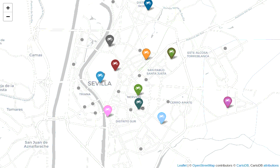
Move the world smarter


.png)


